We have learned to think of Australia’s grid of roads and highways as ecological ‘non-places’. Tracing a trail to its end allows an undoing of infrastructure, and a reminder of the floodplain, wetland, scrub and forest beneath the bitumen.

There are two other cars at the end of the road. On one, a bumper sticker reads, ‘Caution: driver will suddenly STOP if they spot hawkweed!’ On the other, a hand-scrawled dashboard note: ‘Gone birding (hooded plover), back Sunday.’
I have been searching for a real dead end: not simply a cul-de-sac, but a place where the world’s grid of streets and highways meaningfully cease, giving way to land that can only be travelled on foot—or, better yet, not passed through at all. Increasingly, this represents a challenge. The planet is enmeshed in a net of asphalt that is woven more tightly by the year. Find an atlas, close your eyes, and point: if you hit land, you can almost certainly find a way to drive there.
On Google Maps, it is possible to tinker with the display settings, turning off every conceivable landmark—parks and buildings, mountains, rivers, oceans—until roads are all that remain. The lattice slackens and tightens as you pan, serving as a proxy for human density, but almost nowhere are the gaps so great as to render the outlines of continents illegible. From the air, global road networks now resemble organic systems, with distributors and arteries unfurling as arboreal fractals.
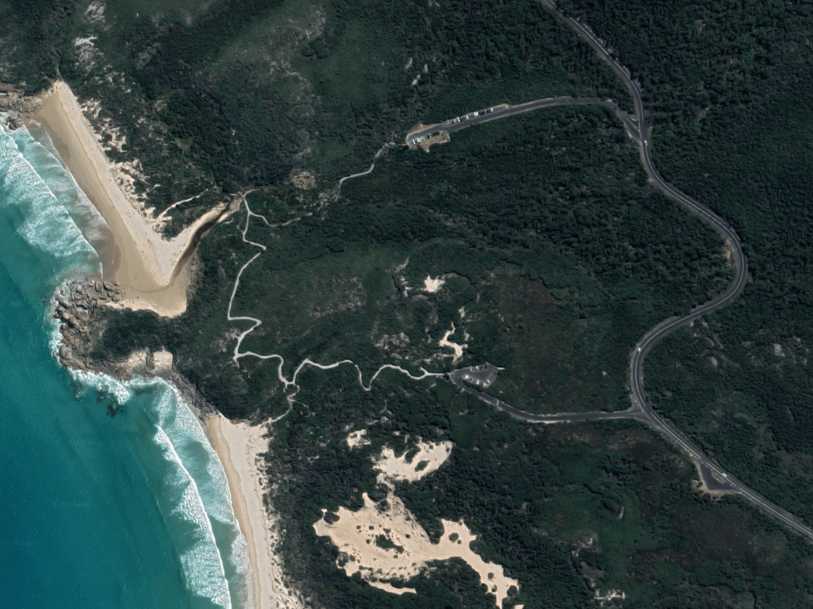
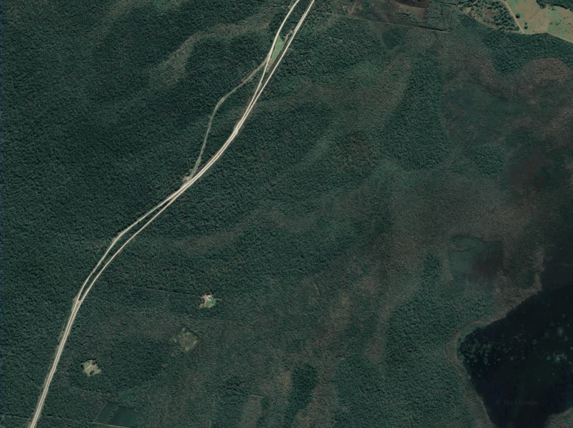
I’ve found the end of the road closest to me: a single lonely squiggle, several hundred kilometres from Melbourne, trailing off down the southernmost end of the Australian mainland. It took me three hours to reach its terminus, which revealed itself to me as a trailing off: from paved high-speed freeway, to gravel road, to emergency access track—then, beyond, a narrow bush path worn by footfall, which will itself eventually give way to scrub that admits travellers in exchange for scratches and splinters. At each juncture, a slowing of speed and a change in modality. To trace this trail is an undoing of infrastructure.
*
A roadway doesn’t simply provide for human access. It slices through a landscape, breaking it into pieces. The world is now split into more than half a million of these fragments, trapping animal genetics between intersecting highways.
On my way to the end of the grid, I travelled along the C443, which loosely traces the Tarwin River. But while the river’s divide weaves ecosystems across the riparian margin, the road—or, rather, what is funnelled along it—kills much of what tries to pass. There is a particular intersection in which remnant bushland has created a loose strand of connection from river to road. Here, the roadside was lined with several wombats, their stout bodies upturned.
A roadway doesn’t simply provide for human access. It slices through a landscape, breaking it into pieces.
Earlier in the drive, upon slowing to avoid what I believed was a rock in the road, I had noticed movement: a rapid retraction of head into shell. A snake-necked turtle, now stranded far from safety. Correctly, it had identified me as a threat.
We are used to thinking of roads as conduits to elsewhere—as liminal zones that don’t exist in their own right. If an animal appears on the road, it is because they have carelessly found themselves out of place. If they are struck by a passing car, these irresponsible jaywalkers enter a unique state of unbelonging: ‘roadkill’. The term erases both subject and object: a nothing, killed by nothing. In most countries, most of the time, these deaths go entirely unrecorded.
In 1989, by the side of the Newell Highway, fifty kilometres from Dubbo, performance artist John Reid stripped and lay naked beside a dead kangaroo. Twenty-five vehicles passed without slowing. Decades later, Reid was charitable in his assessment of his ‘audience’. Perhaps, he reasoned, the drivers were able to easily ‘differentiate between life and art’. A photograph of the ‘performance’ is more difficult to ignore. Initially, it registers as darkly funny—the surface humour of something out of place—but the joke collapses quickly.
Until recently, there were relatively few studies of roadkill in Australia. Environmental scholars Kate Rigby and Owain Jones suggest this may be because the ‘routine sight of animal corpses on modern roadways’ has long been viewed as essentially ‘unremarkable’. Another possibility is that there is little to do with animal fatality information, once collected. Even partial solutions—reduced highway speed limits, night driving curfews—are rarely seriously entertained. The acceptance of animal death seems to be a trade-off made, long ago, for high-speed human travel.
It took decades for the automotive lobby to convince human beings that roads should be considered non-places. Early twentieth century streets were the commonest commons: by their very nature, they were spaces for human and animal rambling, their surfaces designed for feet and hooves. There is still an ecology of roads, though. We are simply invited to ignore it.
*
I am here, now, at the end of it. The southward squiggle of roadway has conveyed me across the narrow, sand-duned corridor known as the Yanakie isthmus, and on to Wamoon—the weathered granite peninsula commonly referred to as Wilsons Promontory.
Much of the northern section of the Prom is designated as a ‘wilderness zone’, which legally prohibits the construction of new vehicle tracks. A single gated emergency access road threads through the zone. Does this count as part of the grid? From the perspective of a marsupial, such a distinction is unimportant. What is critical is whether the clearing is safe to cross.
It took decades for the automotive lobby to convince human beings that roads should be considered non-places.
A wombat steadily, but without caution, manoeuvre its bulk across the track. When it passes into the scrub, there is no change to its pace or demeanour. I realise, absurdly, that this is the first time I have seen a wombat cross a road. As a species, the common wombat’s range is vast—stretching from Tasmania to southernmost Queensland—but much of that territory now requires the creature to navigate an uncertain existence with Highway 1. Animals that are born in wilderness zones are afforded a vanishingly rare form of safety from a curiously capricious predator.
*
In one sense, Australia’s road network is now the only unfractured ecosystem on the continent. By its nature, in order to function, a roadway must be continuous. A driver from Melbourne can pass along five thousand kilometres of unbroken asphalt to reach Broome in the north-west. If the surrounding environment intrudes—in the form of a fallen eucalypt, or pooling rainwater attempting to return sections of the highway to natural floodplain—transport department workers are ready to restore the road to its unspoiled state. There are no rivers of this length in Australia, and the longest—the Murray and the Murrumbidgee—are both now dammed, split into disconnected linear successions. On land, the only creature that can now traverse Australia entirely unimpeded is a car.
There is a myth that urban Australia is tightly clustered, with bushland beginning at the suburban border, stretching on unbounded and infinite. But where, exactly, is this unbounded and infinite bush? It is the very land that was once the most densely vegetated that has been paved over. Maps outlining the extent of suburban sprawl overlay almost perfectly on flora maps marking out eucalyptus forest and humid woodland. In Victoria, the most cleared state in Australia, it is now impossible to travel more than eight kilometres from a public road—to the northernmost tip of Wilsons Promontory. Elsewhere in the state, it is possible to hike more than eight kilometres without passing a roadway, but such trails must be carefully designed, looping internally or strategically weaving into remnant bushland, creating an illusory impression of isolation.
Other Australian states, still with considerable expanses of roadless space, are in a complex position. There exists an opportunity to protect great swathes of land, linking forests, floodplains and grasslands into connected, free-flowing ecosystems. As a rule, though, unprotected tracts of bushland in Australia continue to serve as placeholders. If such land if neither national park nor state forest, it takes the form of marginal or ‘unused’ space, waiting for the erection of the inevitable billboard marketing its profitable excision into saleable quarter acres. If the land is already farmland, the case for suburban development appears even simpler, as the land has already been ecologically degraded.
On land, the only creature that can now traverse Australia entirely unimpeded is a car.
In New South Wales, one planning document envisages six large coastal cities eventually merging to form a 300 kilometre-long megalopolis from Newcastle to Bateman’s Bay. In one mockup, a raised roadway passes through the eucalypt forest that houses the state’s sole remaining healthy koala colony.
Aerial photographs, meanwhile, reveal the ‘filling-in’ of the Cumberland Plain, west of Sydney. Remnant forests are squeezed between roadways, their new borders taking the form of sweeping AutoCAD curves. On these plains, the land that is most vulnerable to roadway expansion is native grassland—in part because these ecosystems fail to align with dominant ideas of wilderness, and instead invoke the fear of an uncanny, unkempt pastoralism: a farm with no owner, left to run amok. Lacking a picturesque treescape to catch the eye, the ecological complexity of grasslands reveals itself only after careful observation. The speed of outward suburban development continues to outpace our ability to fully register what is being destroyed to achieve it.
In some ways, the logic of expansion is difficult to contest. Where else, after all, can these cities go? But everywhere, the grid is tightening. Plants and animals cannot be picked up and shifted into clusters of human convenience.
Advocates of increasing urban density are forced to contend with a challenging truth: many of us inexorably drawn to sprawling outward suburbia, even those of us who should know better. Near the end of Green Metropolis, a heavily-researched 368-page advocation for ‘living smaller, living closer, and driving less’, author David Owen eventually concedes that he still lives an ‘extravagantly wasteful life’ in rural Connecticut because, well, he doesn’t want to live near the city. We may find the thought of laying a road grid over native grassland horrifying, but, once a new suburb fills out the asphalt lattice, we may very much want to live there.
*
In order to proceed through the Promontory’s northern circuit, walkers must fill out a self-assessment form, acknowledging they understand the risks of travelling away from roads. Tick-boxes require hikers to consider how they might navigate in the absence of land features, or safely exit the area in case of emergency.
Streets now function as our primary geographic markers, their splitting of the landscape into bisecting, labelled lines creating an increasingly specific locative shorthand. The world underneath disappears, both literally and figuratively. For most of us, most of the time, an address reduces down to ‘a place on a road’.
I am no longer on the emergency track, but have turned onto a narrow trail that weaves through the tea trees, their prodigiousness across this landscape itself a product of human disturbance. While initially the path is obvious, in places it collapses to nothing at all, the intended course indicated by flagging tape wrapped to the branches of far-off banksias. Faint indications of worn earth reappear, visible between the starbursts of austral grasstrees. The path, where it does exist, is a desire line, held in place by others who have moved through before me. On my topographic map, there is a faint doubling of the trail in places—a splitting and eventual reunion—which is unexplained in the key. With nothing to hold it in place, the path seems to have changed course over time. Perhaps the map-maker decided it was safest to hedge their bets, unsure of which track would eventually disappear and which would gain validity through reinforcement. More than once, I focus so closely on the trail markings on the map that I lose my way. I am used to a map as the authoritative measure of the world, failing to recognise that the world, left to its own devices, does not naturally remain fixed in place.
On an outcrop littered with granite way-finding cairns, I meet two park rangers travelling back to the emergency road. They’ve been hiding camera traps throughout the wilderness zone in the hope of tracking feral deer. The unique position of the Promontory, accessible by land only through the narrow isthmus, means that it may be possible—in theory—for the park to eventually function as a sanctuary, free of invasive species. Without roads, though, it is more challenging to identify exactly what is happening in the wilderness. Massive Sambar deer were rumoured to exist on the Promontory for years before one was eventually remotely photographed. There may be thousands of deer, of multiple species, currently on the peninsula.
As they leave, one of the rangers sheepishly nods beyond the outcrop. ‘Be careful,’ they say. ‘We lost the trail completely a little way up there.’
*
Roads can be constructed carefully, in a kind of dialogue with the land, but most often, the earth is regarded as an impediment to a target of perfectly linear efficiency. A highway that can cut straight through a mountain or pass over a river is quicker to traverse than one that meanders. Paths for walking, usually, do not follow this pattern. Instead, they flow with the landscape.
Walking trails that become roads bear this distinctive character. There is a Wathaurong phrase, ‘kooly bar ghurk’, which refers to tracks made by the creek. In Meredith, west of Melbourne, there is a Coolebarghurk Road, its name holding a trace of its history. There have been thousands of other trade routes passing through Australia for tens of thousands of years, some of which have been reinscribed and paved over. In turning these routes into roads, they have been made permanent while their origin is erased.
I am used to a map as the authoritative measure of the world, failing to recognise that the world, left to its own devices, does not naturally remain fixed in place.
In Sydney, streets are topographically aligned, meandering with the contours of the landscape. As D’harawal academic Shannon Foster suggests, a careful exploration of these streets—how they curve, and where they lead—reveals that many were never meant for driving. Instead, they have emerged from ancient trails, ‘carved through the bush with the clever and skilful use of firestick farming’.
Melbourne’s Hoddle Grid, meanwhile, is rigidly right-angled, bearing no trace of the paths that preceded it. An 1837 map of the site reveals a mosaic of hills, wetlands, she oak woodlands, salt lake, and tea tree scrub. There is one curious track, which curves in a sweeping arc from what is now the intersection of Flinders Lane and Queen Street, proceeding north-west between three hills, toward a saltwater river. The first hill the track passed was known in Boonwurrung language as ‘Barebeerip’. By 1892, it had been completely removed, the land levelled. In the years since, the city’s road network has expanded as almost every natural feature has been suppressed, razed, and filled in with concrete. Hoddle’s ‘Mile Grid’ extends beyond the CBD, serving as the city’s original blueprint for suburban sprawl. At points, it is now possible to drive in a perfectly straight line for more than ten kilometres at a time. It is impossible to believe that nothing of significance existed along those neat, uncompromising lines.
In late 2020, near the Victorian township of Buangor, a sacred eucalyptus melliodora—a Djab Wurrung directions tree, born of a seed planted alongside a newborn child’s placenta—was felled to make way for a highway extension. When tabling her investigation into the highway project in Victorian Parliament, Ombudsman Deborah Glass argued that agencies had ‘made considerable efforts to minimise the damage to Aboriginal cultural heritage’ because sixteen of twenty-two culturally significant trees would be retained as the result of consultation. Put another way, this served as an acknowledgement that the Victorian government admitted that at least six sacrosanct trees would be destroyed.
In Australia, road infrastructure consultations continue to follow a pattern that almost always find in favour of the highway: an initial plan is devised that slices through a sacred site, with communities turned against one another as they are suddenly forced to document sanctity in a form that is interpretable to bureaucrats. If a tree has not been visibly modified, scarred or burned, the burden of proof is raised too high to clear. By the end of the process, a concession is offered: the construction project will continue, roughly as planned, but a few of the sacred trees will be generously spared. There is something particularly cruel about sacred spaces being destroyed to make room for highway—a non-space that is simply a conduit to moving us elsewhere. As one oral submission to the investigation suggested, when the lines of the transport network cross a songline, it is the songline that planners will repeatedly decide to break.
*
A tiger snake glissades across the path. In a grove, some banksias sleep with their pod eyes closed, some with one eye open, huddled in their hundreds. On the ground, other pods are collapsing back into the earth, each developing a gnarled uniqueness in the process of decomposition. As the contour lines fall away, the track becomes swamp.
I find the Lower Barry Creek campsite shortly before sunset, a wooden sign serving as the area’s only permanent infrastructure. By the creek, I listen for the absence of traffic hum. Road noise—an A on the musical scale, sometimes swaying into a flat or sharp—is identical in frequency to the reference tone used in audio engineering.
Like light pollution, road sounds permeate environments far from their source. We are good at mentally nullifying both types of disturbance, such that a fuller silence or darkness can initially register as eerie, or disorientating. By the creek, the four hundred hertz flight tone of mosquitos neatly fills in the silence.
*
The construction of roadways triggers what is sometimes referred to as ‘contagious development’. Roads beget roads. A street that leads nowhere is useless—and once a road passes through a wild area or part of a greenbelt, the cost to extend it is minimal. As our baseline shifts, we forget what existed before. New suburbs on the outer ring of Australian cities begin as tributaries, feeding out of fields and onto the freeway. A few years later, there is no trace of the land underneath.
There is something particularly cruel about sacred spaces being destroyed to make room for highway—a non-space that is simply a conduit to moving us elsewhere.
Sluggish traffic seems to bear only one solution: the construction of more lanes through which it may flow. Counterintuitively, this almost always has the opposite effect. As new roadways are opened, demand is induced.
Globally, there have been effective campaigns of resistance. In the early 1970s, over the cover of night, residents of a small street in the Dutch town of Delft simply removed their road from the city’s grid. Tree-flanked concrete barriers at both ends prevented the passage of cars, reclaiming the cobble-stones as a play space for children. Throughout the decade, streets in other Dutch cities were similarly claimed back as woonerven (‘living streets’)—sometimes permanently through the erection of bollards or shrewd placement of potted plants, or temporarily, through organised dinner parties or ‘play days’ in which parents and their children occupied a road. The campaign was not adversarial: drivers and politicians, after all, were parents, cyclists, and pedestrians too.
Over the span of several years, grassroots changes to the structure of Dutch cities were formalised and endorsed. In late 1973, spurred both by activism and the Opec oil crisis, the government of the Netherlands banned driving entirely on Sundays for several months. By 1977, The Hague and Tilburg had introduced ‘Demonstration Cycle Routes’—the world’s first modern, specially-marked cycleways. By 1990, the average Dutch resident was cycling a third more often than during the late 1970s. Over the proceeding decades, as the cycling rate cratered elsewhere, in the Netherlands it remained stable. While the Dutch road network is one of the world’s densest, it is a space in which the encroaching dominance of motor vehicles continues to be actively contested.
*
I return to the road the way I came, curious about whether I will lose my way in the re-tracing. This time, instead of resolutely following the map’s trail markings, I use the world to take my bearings: the flower spikes of an Xanthorrhoea in the distance, the gradient of earth fading into swamp.
*
The land beneath our cities’ grids served as floodplain, wetland, scrub and forest, all effaced by the ecology of the road. What was once beneath the road in front of our homes? What is still underneath it, if we were to jackhammer the bitumen away? Sometimes, in flood, the original ecology reasserts itself: water, unable to soak into the ground, rises and gathers force.
Once a road is built, it is almost impossible to remove it entirely. It forms the lattice upon which the human world is built. But roads can be gradually unmade, and returned to the commons—a place, rather than a link between places. Beneath the pavement, the beach.
This essay was a runner up in the 2022 KYD Creative Non-Fiction Essay Prize.


